
Low altitude remote sensing-ground sensing double collection system for farmland quality
-
摘要:目的
将无人机(UAV)低空遥感检测系统与无人机−无线传感器网络(UAV-WSN)集成,实现通过一套系统进行低空遥感监测和地面长期监测的双重监测,为耕地质量的空间和时间变化提供监测数据。
方法本研究探讨了现有UAV-WSN系统无法实现双重采集的问题,设计了一套用于耕地质量监测的低空遥感−地面传感双重采集系统,提出一套双重采集的工作流程,以及提升性能的基于航线的LEACH算法。仿真分析试验中调整UAV飞行高度和地面节点密度,以比较双重采集系统和UAV-WSN系统总飞行时间的不同。
结果双重采集系统1次飞行同时采集2种监测数据,无需完成低空遥感监测数据采集后再次走遍所有地面节点,在低空遥感地面图像分辨率变化的情况下,总飞行时间比UAV-WSN系统快165 s;双重采集系统根据无人机航线和地面节点位置进行调整,在地块内节点数量变化的情况下,总飞行时间基本不变,比UAV-WSN系统快129~194 s。
结论双重采集系统能够减少现场采样所需的总工作时长,降低采样工作的复杂程度,提升耕地质量监测的效率。
Abstract:ObjectiveTo integrate unmanned aerial vehicle (UAV) low altitude remote sensing system and unmanned aerial vehicle-wireless sensor network (UAV-WSN), realize double monitoring of low altitude remote sensing monitoring and ground long term monitoring through one system, and provide monitoring data for space and time changes of farmland quality.
MethodThe study explored the problem that current UAV-WSN system cann’t collect long-term monitoring data from sensor nodes on the ground and low altitude remote sensing data from UAV’s sensor at the same time. A low altitude remote sensing and ground sensing double collection method and system for farmland quality monitoring was designed, and the key steps and algorithm for integrating these two monitoring systems were studied. Adjusting UAV flying altitude and ground node density in simulation analysis experiments to compare total flying time differences of double collection system and UAV-WSN system.
ResultDouble collection system could collect two kinds of data in one flight, UAV don’t need to fly over every ground sensor node again after collecting low altitude remote sensing data. When the ground image resolution was changed, the total flying time of double collection system was 165 s faster than UAV-WSN system. Double collection system could adjust based on UAV flight path and ground sensor node location. When the number of sensor nodes was changed, the total flying time was not changed and 129−194 s faster than UAV-WSN system.
ConclusionDouble collection system can reduce total operating time and complexity of sampling, and increase the efficiency of farmland quality monitoring.
-
耕地质量监测的监测指标数量和种类较多[1],常规的现场调查与实验室化验分析方法虽然能够获得绝大部分耕地质量监测指标数据,但现场调查的主观影响大,实验室化验费时费力,调查数据无法展现耕地质量指标的空间和时间变化。如果能够获得监测区域的地面长期监测数据和低空遥感数据,就可以为耕地质量指标的监测提供新的监测和分析方法[2]。现有的无线传感器网络和无人机可以分别提供地面长期监测数据和低空遥感数据。
无线传感器网络可以进行地面长期监测。作为物联网的重要技术之一,无线传感器网络一直是国内外的研究热点,并已广泛应用于农业生产[3-6]、环境监测[7-9]、地质检测[10-11]、文化遗产保护[12-13]等领域。传统的无线传感器网络受到丘陵、农作物等地貌地物的影响,容易出现无法通信、丢包率大或者能量消耗不均匀的问题[14-16]。在无人机上搭载汇聚节点形成立体无线传感器网络,可以利用无人机在低空、超低空飞行不受地形和环境影响的特点实现汇聚节点的移动,防止节点之间被农作物遮挡导致数据无法传输[17-21]。
无人机低空遥感可以进行区域低空遥感监测。无人机采集的数据具有高空间分辨率和高空间精度的特点,是近年来热门的遥感监测技术,可以用于精准农业航空[22-26]、土地利用监管[27-28]、地形测绘[29-32]等领域。与卫星遥感相比,无人机低空遥感可以采集到更高空间分辨率的图像或光谱数据和更优质的遥感数据,并且采样成本低[33-35]。
但是,现有的无人机−无线传感器网络(UAV-WSN)系统无法直接成为一套双重采集系统。UAV-WSN系统中无人机只是作为移动汇聚节点获取地面节点数据,无法获取低空遥感数据;或者无人机只是作为采样设备采集低空遥感数据,无法保证能够完整获取地面节点数据。现有的UAV-WSN系统需要以不同的方式和不同的航线采集低空遥感数据和地面长期监测数据[36-43]。直接将2种采集合并,无人机采集的图像数据就无法拼接为低空遥感数据,或者无人机无法完全汇聚所有地面节点长期监测数据。
本研究设计了一种用于耕地质量监测的低空遥感−地面传感监测双重采集方法及系统,1次采样飞行同时获取完整的地面节点长期监测数据和低空遥感图像数据2种监测数据。其中的关键技术在于设计1套全新的双重采集工作流程,并且对原有的2套技术方案关键步骤和算法进行有效的融合与更新,使之成为适用于本发明的双重采集步骤与算法。通过立体无线传感器网络和无人机低空遥感的集成与融合,能够减少现场采样所需的总工作时长、降低采样工作的复杂程度、提升耕地质量监测的效率。
1. 双重采集系统设计
1.1 双重采集思路
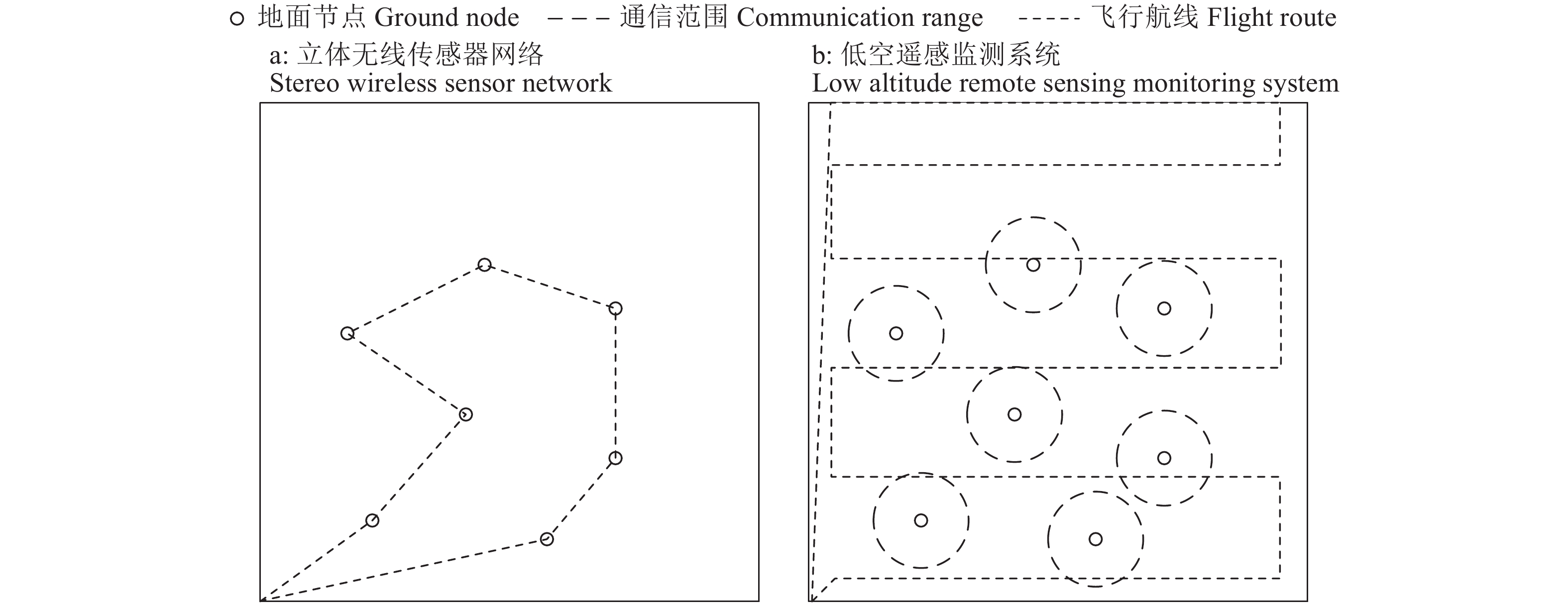
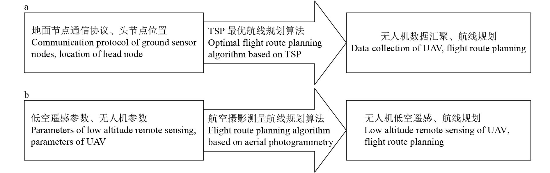
现有立体无线传感器网络监测和低空遥感监测系统的主要思路分别如图1所示。图1a显示立体无线传感器网络根据地面节点分簇后的头节点位置确定无人机航线,图1b显示低空遥感监测系统根据机载相机或光谱成像仪的参数确定无人机航线。
![]() 图 1 立体无线传感器网络(a)和低空遥感监测系统(b)技术方案Figure 1. Solutions of stereo wireless sensor network (a) and low altitude remote sensing monitoring system (b)
图 1 立体无线传感器网络(a)和低空遥感监测系统(b)技术方案Figure 1. Solutions of stereo wireless sensor network (a) and low altitude remote sensing monitoring system (b)如果将立体无线传感器网络和低空遥感监测系统直接合并为同一套系统,由于这2套系统的数据采集原理与航线规划方法不同,依旧无法实现1次飞行任务采集2种数据。如果以立体无线传感器网络的技术方案为主同时采集低空遥感图像,所采集的图像数据不仅分布不均匀,而且无法拼接为整个区域完整的低空遥感数据,如图2a所示。特别是应用了分簇路由协议的立体无线传感器网络,由于是动态组网,每次分簇组网的头节点不同,航线也会不同,所采集到的地面图像数据的位置也就完全不同。如果以低空遥感监测系统的技术方案为主同时采集地面节点数据,由于航线规划过程不考虑地面节点位置,这就很可能会出现无人机不经过地面节点分簇后的头节点的有效通信范围,导致地面数据无法发送至无人机;或者无人机经过地面节点分簇后的头节点有效通信范围的航线长度太短,头节点没有足够的通信时间将数据全部传输至无人机,如图2b所示。
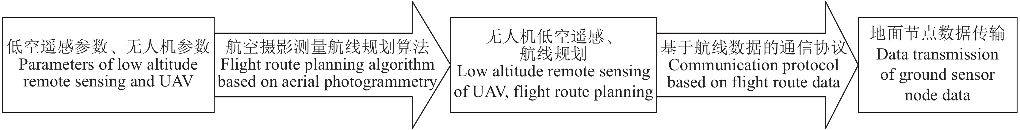
由于没有可以同时满足立体无线传感器网络系统和低空遥感监测系统的航线规划算法,本研究创新一种双重采样技术方案,主体思路如图3所示:根据机载相机或光谱成像仪的参数确定无人机航线,通过无人机航线数据进行地面节点分簇和数据传输,再通过地面节点来提升无人机低空遥感数据精度。
![]() 图 3 低空遥感−地面传感监测双重采集系统技术方案Figure 3. Solution of low altitude remote sensing-ground sensing double collection system
图 3 低空遥感−地面传感监测双重采集系统技术方案Figure 3. Solution of low altitude remote sensing-ground sensing double collection system1.2 双重采集系统硬件设计
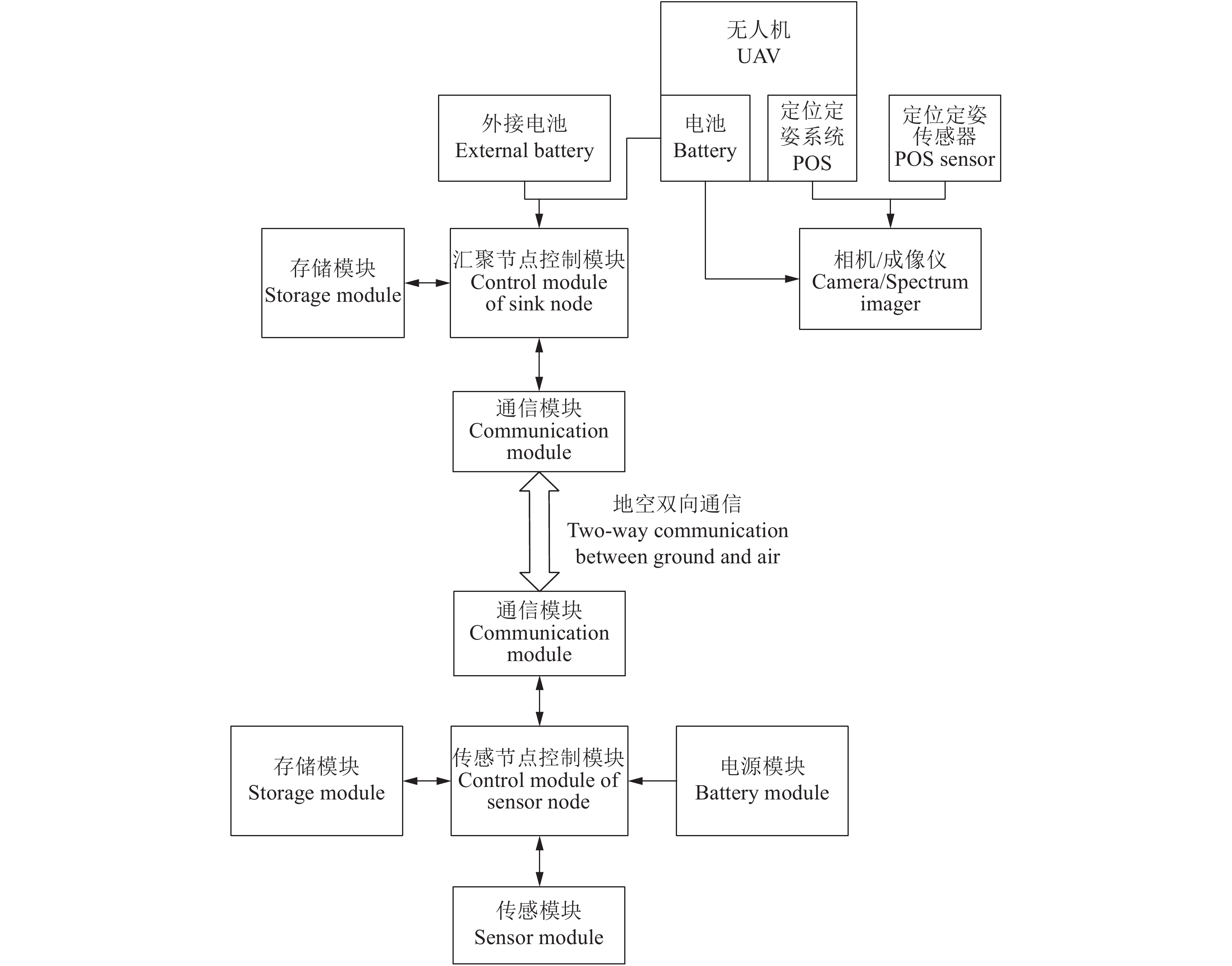
双重采集系统硬件架构分为2部分:地面节点和空中无人机(图4)。地面节点与常规无线传感器网络的传感器节点相似,主要包括控制模块、采集模块、通信模块、存储模块、电源模块、太阳能板。采集模块根据监测需求搭配不同的传感器,例如用于耕地质量监测,分别可以选择搭配三深度土壤含水量传感器、土壤pH及EC传感器、气象站、叶面积指数传感器等。通信模块根据耕地大小和分布进行调整,常规情况下搭配各类低功耗ZigBee模块,减少通信方面的能耗以增加地面网络整体生存时间;耕地地块小、破碎化程度高的情况下搭配WiFi模块,提升数据传输速率,尽可能多得采集地面情况;耕地面积广、与固定翼无人机配合的情况下搭配LPWA模块,提升通信距离以实现与飞行高度较高的固定翼无人机进行数据传输。
空中无人机平台是一台无人机搭载2种机载功能模块,包括低空遥感数据采集和地面传感数据汇聚。根据监测需求低空遥感数据采集可以选择高清相机、热成像相机、多光谱相机、高光谱成像仪等,并且利用无人机自带或额外加装的定位定姿系统(Position and orientation system,POS)在记录图像、多光谱相片等数据的同时给每张相片附加对应的经纬度、高度、三轴翻滚角和光照强度。地面传感数据汇集由控制模块、通信模块、存储模块和电源模块组成。通信模块选取与地面传感器节点所选取的通信模块类型相同的模块,如果所选类型为ZigBee或者LPWA,需要额外附加WiFi模块用于与移动实验室通信。电源模块根据无人机进行调整,如果无人机提供电源接口,电源模块使用调压模块连接无人机;如果无人机没有电源接口,电源模块为高容量电池。
2. 低空遥感−地面传感双重采集方法
2.1 双重采集设计
将立体无线传感器网络和无人机低空遥感这2套监测系统进行集成,需要解决2个问题:如何让地面节点集群的数据传输适应无人机的飞行航线,如何利用地面节点集群提升低空遥感效果。
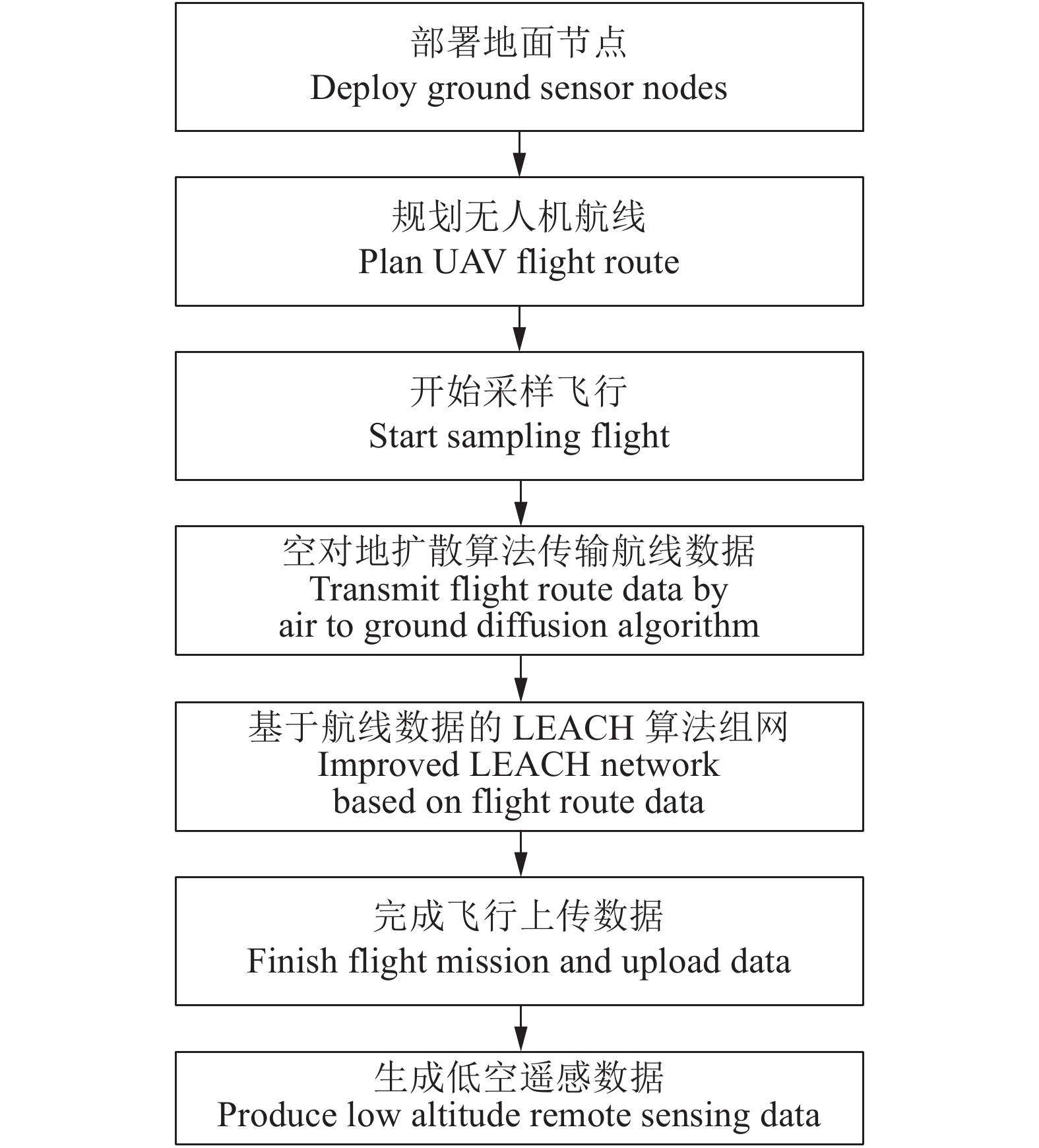
整个系统的工作流程如图5所示。工作人员部署地面节点时,测定每个地面节点的太阳能板的经纬度和海拔高度,将太阳能板作为低空遥感图像拼接过程所需的地面控制点(Ground control point, GCP);每次采样飞行前,规划好的无人机飞行航线会同时传入无人机飞行控制器和无人机上的汇聚节点;在无人机采集低空遥感图像的过程中,汇聚节点会不断向地面发送组网信号,地面节点集群中任意一个节点接收到组网信号后与汇聚节点通信并接收航线数据,然后使用定向扩散协议将航线数据传输给所有地面节点;地面节点集群使用基于航线的LEACH路由协议选取头节点并将数据发送至头节点,由头节点将数据传输至汇聚节点;无人机的低空遥感图像数据和地面节点传感数据上传至远程服务器的PhotoScan图像拼接软件,在PhotoScan拼接图像的过程中人工识别每个作为GCP的地面节点太阳能板并录入经纬度以提升几何精度,PhotoScan继续进行拼接任务生成鸟瞰图、数字高程模型(Digital elevation model,DEM)等低空遥感产品[44]。
让地面节点集群的数据传输适应无人机的飞行航线,关键在于将航线作为参数进行地面节点的组网。通过将航线数据传遍所有地面节点并基于航线数据进行分簇组网,可以保证每个簇都将数据顺利传输给无人机上的汇聚节点,同时兼顾地面节点集群的能量均衡。
利用地面节点集群提升低空遥感效果是指将地面节点作为地面控制点。对于低空遥感监测系统,如果人工部署GCP,虽然能够将水平方向的误差降低至0.51 cm[45],但是需要工作人员走遍整个监测区域选取地物或放置靶标作为GCP并测量经纬度,完成测量后再走遍整个区域回收靶标,花费的时间和人力远远高于无人机飞行航拍的过程;如果不部署GCP,虽然工作人员仅需站在无人机起飞点观察和等待无人机完成飞行航拍,但是水平方向的误差为1~2 m。双重采集系统使用坐标点已知、位置固定、形状规整的地面节点集群的太阳能板作为地面控制点,工作人员在采样过程中不需要走遍整个区域部署地面控制点,而是在拼接图像时人工识别每个地面节点的太阳能板并录入该地面节点的经纬度。因此双重采集系统可以在保证低空遥感数据几何精度的同时免去每次飞行前人工部署地面控制点的人力和时间成本[45-46]。
2.2 基于航线的LEACH算法
为了让双重采集系统的地面节点集群组网及数据传输适应无人机的飞行航线,本研究以经典的LEACH算法为基础,设计了基于航线的LEACH算法。经典LEACH算法纯以概率均衡地面节点集群能量消耗,直接用于双重采集系统有可能出现头节点与无人机通信时间过短甚至无法与无人机直接通信的情况。本研究设计的算法中,无人机经过有效通信区域的航向长度越长的节点被选为头节点的几率越大,而无人机不经过有效通信区域的节点被选中的几率为0。
如果有n个地面节点,每个节点获取到无人机的航线数据后,会根据自身的经纬度计算无人机飞过能够进行数据传输的有效通信区域的航线长度ln,然后计算Tn。接着每个节点随机生成1个(0,1)之间的数,如果该节点生成的数小于Tn则为头节点,Tn计算公式如下:
$${p_n} = \frac{{p \times {l_n}}}{{\sqrt {{d^2} - {h^2}} }},$$ (1) $$T_n = \left\{ {\begin{array}{*{20}{l}} 0&,{{n \notin G}}\\ {\dfrac{{{p_n}}}{{1 - {p_n} \times \Bigg(r\bmod \dfrac{1}{{{p_n}}}\Bigg)}}}&,{n \in G} \end{array}} \right.$$ (2) 式中,p是网络中所需头节点数目与总的地面节点数目的比值,Pn是p经过有效通信距离作为权重进行加权后的值,Tn是节点当选为头节点的阈值,ln是无人机飞过节点n的有效通信范围的航线长度,d是最大直线通信距离,h是无人机飞行高度,r是当前选举轮数,G是在剩余1/p轮中非头节点的节点集。
选出头节点后,头节点会通过定向扩散协议向整个地面节点集群发送当选信息和自身坐标。如果地面节点集群内本轮出现多个头节点,则其余节点根据距离选择最接近自己的头节点进行组网。每个节点会将自身信息和路由沿着从头节点定向扩散路径的反方向发送给头节点。头节点根据反向回馈的节点信息为每个成员节点分配相应的TDMA时隙表,错开各个节点发送数据的时间,避免信息拥堵。头节点完成收集所有成员节点的数据后,当无人机飞入头节点有效通信范围内时,头节点将数据发送至无人机的汇聚节点。
本步骤是实现地面节点配合无人机航线,而不是常规的无人机航线配合地面节点的关键。通过将航线数据融入LEACH算法,可以在均衡地面节点集群能量消耗的同时提升数据传输效率。
3. 仿真试验与结果
3.1 仿真设置
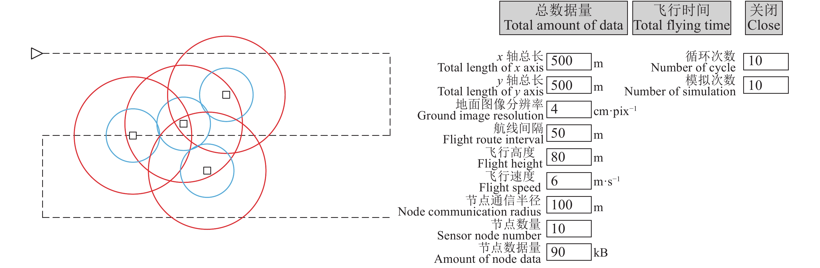
本研究开发了一套低空遥感−地面传感双重采集仿真器,用于仿真双重采集系统双重采集任务的过程数据(图6)。现有的仿真器大多只是针对无人机飞行或者常规无线传感器网络数据传输,不能同时仿真无人机飞行、低空遥感数据采集以及针对立体无线传感器网络数据传输的软件。因此本研究针对低空遥感−地面传感双重采集的特性,使用C#编写了双重采集仿真器进行性能仿真试验。
![]() 图 6 低空遥感−地面传感双重采集仿真器“□”表示地面节点位置,“▷”表示无人机位置,“−−−”表示无人机飞行航线,“◯”表示地面有效通信范围,“◯”表示无人机所在高度的水平面上的有效通信范围Figure 6. Emulator of low altitude remote sensing-ground sensing double collection“□” indicates ground node location, “▷” indicates UAV location, “−−−” indicates UAV flight route, “◯” indicates effective communication range on the ground, “◯” indicates effective horizontal communication range in the altitude of UAV
图 6 低空遥感−地面传感双重采集仿真器“□”表示地面节点位置,“▷”表示无人机位置,“−−−”表示无人机飞行航线,“◯”表示地面有效通信范围,“◯”表示无人机所在高度的水平面上的有效通信范围Figure 6. Emulator of low altitude remote sensing-ground sensing double collection“□” indicates ground node location, “▷” indicates UAV location, “−−−” indicates UAV flight route, “◯” indicates effective communication range on the ground, “◯” indicates effective horizontal communication range in the altitude of UAV在实际应用中,地面节点集群中各个节点的分布受耕地形状、田间设施等因素的影响,基于航线的LEACH算法按不同概率选取头节点,两者都有不确定性。本次模拟试验使用最简单的随机布点法模拟地面节点的分布,使用蒙特卡洛法进行大量模拟,通过上万次的随机布点获取不同情景下采样的总飞行时间。
本次仿真试验设定的监测区域为500 m×500 m的正方形区域,无人机使用大疆精灵3 Advanced,地面节点的通信模块使用CC2530。CC2530最大通信距离为100 m,通信频率2.4 GHz,平均传输速率3 kB/s。大疆精灵3 Advanced最大飞行速度为16 m/s,最大飞行时间23 min,相机为1/2.3 CMOS传感器,镜头FOV94° 20 mm,相片分辨率4 000×3 000。规划航线时,旁向重叠率设定为30%,航向重叠率设定为60%,飞行速度设定为10 m/s。
3.2 结果
仿真试验中分别调整无人机采集图像的地面分辨率和监测区域内地面节点数量,即无人机飞行高度和地面节点密度,以此来对比本研究的低空遥感−地面传感双重采集系统与UAV-WSN系统分别采集地面节点数据和低空遥感数据的方法在总采样飞行时间上的不同。
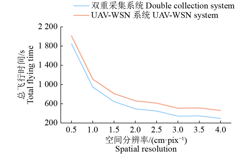
图7为地面图像分辨率变化时的时间曲线。随着地面图像分辨率增加,无人机飞行高度增加,航线密度减小,进行低空遥感图像采集的飞行路程减少,总飞行时间整体呈下降趋势。由于双重采集系统只需1次飞行就能采集2种数据,因此总飞行时间更短,比UAV-WSN系统快约165 s。
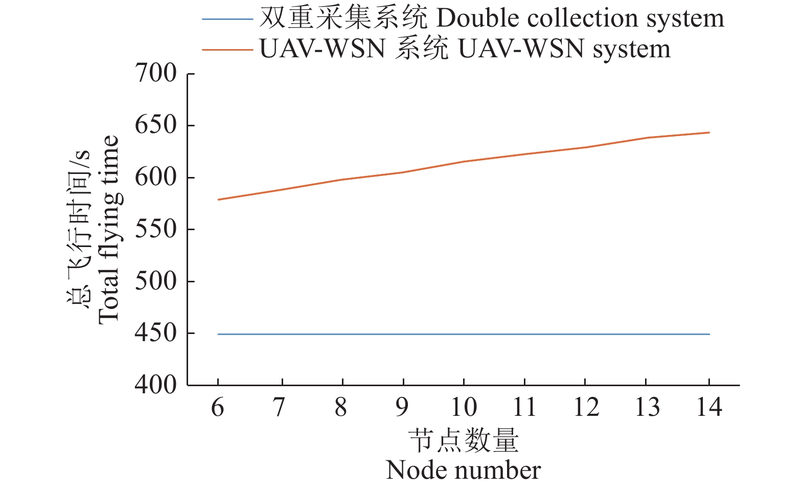
图8为地面节点数量变化时的时间曲线。无人机的飞行高度与航拍所得地面图像分辨率成正比,当地面图像分辨率为3 cm/pix的时候无人机飞行高度为69 m,基本可以保证无人机在耕地上空自动飞行时不会撞上高压线塔等建筑。监测区域计划部署1个气象站采集气象数据、2~6个三深度土壤含水量节点采集耕地内含水量空间分布、1~2个图像节点和2~5个叶面积节点采集作物长势,区域内节点从6个逐渐增加到14个。双重采集系统的航线完全按照航空摄影测量的原理进行规划,总飞行时间保持在450 s不变。UAV-WSN系统总飞行时间随着地面节点密度增加而上升,从579 s上升至644 s。
4. 通信试验与结果
本研究在增城实验基地的稻田内进行了通信试验,测试空中汇聚节点接收稻田地面节点数据的丢包率。地面节点部署在接近稻田边界的地方,无人机搭载汇聚节点悬停在不同高度和水平距离的采样点接收数据。总共设置17个采样点,垂直方向以10 m为起点,以20 m为步长逐渐上升至70 m;水平方向以18 m为起点,以约15 m为步长逐渐移动至60 m。最终设置1个水平距离60 m、垂直高度90 m的最远点,此时地面节点和汇聚节点的直线距离为108.17 m。
从表1的试验结果可得,不同飞行高度的最大通信距离不小于100 m。17个采样点的直线距离为20.59 ~108.17 m,总平均丢包率为1.38%。其中只有4个采样点出现少量丢包,其余13个采样点接收到所有数据包。丢包率最大的是水平距离33 m、垂直高度70 m、直线距离77.39 m的采样点,丢包率9.09%,平均信号强度为−75.75 dBm。其余3个有丢包的采样点丢包率小于5%,平均信号强度为−75.75 ~−50.45 dBm。直线距离最远的采样点没有丢包,平均信号强度为−69.35 dBm。
表 1 通信试验数据Table 1. Test data of communication experiment水平距离/m
Horizontal distance垂直高度/m
Vertical height直线距离/m
Straight-line distance丢包率/%
Packet loss平均信号强度/dBm
Average signal strength18 10 20.59 4.76 −50.45 18 30 34.99 0.00 −60.75 18 50 53.14 4.76 −75.65 18 70 72.28 0.00 −68.40 33 10 34.48 0.00 −54.60 33 30 44.60 0.00 −58.25 33 50 59.91 0.00 −67.70 33 70 77.39 9.09 −75.75 45 10 46.10 0.00 −58.65 45 30 54.08 0.00 −57.30 45 50 67.27 0.00 −67.15 45 70 83.22 0.00 −68.10 60 10 60.83 0.00 −68.85 60 30 67.08 0.00 −60.45 60 50 78.10 4.76 −59.35 60 70 92.20 0.00 −67.70 60 90 108.17 0.00 −69.35 通信试验验证了无人机搭载汇聚节点接收田间地面节点数据的可行性和通信质量。无人机飞行时只要与地面节点的直线距离不大于100 m,基本能够保证良好的通信质量。本研究设计的低空遥感−地面传感双重采集系统的通信验证可行。
5. 结论
本研究设计了一种低空遥感−地面传感双重采集方法及系统,1次采样飞行就能同时获取完整的地面节点长期监测数据和低空遥感图像数据。将原本独立的立体无线传感器网络和无人机低空遥感监测系统融合成低空遥感−地面传感双重采集系统的关键在于对原有的2套技术方案关键步骤和算法进行有效的融合与更新,设计一套全新的双重采集工作流程,以及基于航线的LEACH算法。仿真分析表明双重采集系统与2套系统独立运行相比,总飞行时间更短,更适用于地面节点密度大、监测范围大的情景。立体无线传感器网络和无人机低空遥感的集成与融合,不仅缩短了采样飞行所需的飞行时间和次数,也减少了无人机的电池消耗量、降低了无人机航线规划的难度、减少了工作人员的工作量、提升了现场采样工作的效率。
本研究从集成的角度出发,探索了将立体无线传感器网络与低空遥感监测系统有效融合的架构与方法。集成后的低空遥感−地面传感系统具有与独立无线传感器网络和立体无线传感器网络不同的特性,因此在地面和空中的立体无线传感器网络的数据传输和能量优化、无人机飞行速度和航线规划等方面还能继续进行研究,进一步提升低空遥感−地面传感系统在工作效率、能量消耗等方面的性能。
-
![]()
图 1 立体无线传感器网络(a)和低空遥感监测系统(b)技术方案
Figure 1. Solutions of stereo wireless sensor network (a) and low altitude remote sensing monitoring system (b)
![]()
图 3 低空遥感−地面传感监测双重采集系统技术方案
Figure 3. Solution of low altitude remote sensing-ground sensing double collection system
![]()
图 6 低空遥感−地面传感双重采集仿真器
“□”表示地面节点位置,“▷”表示无人机位置,“−−−”表示无人机飞行航线,“◯”表示地面有效通信范围,“◯”表示无人机所在高度的水平面上的有效通信范围
Figure 6. Emulator of low altitude remote sensing-ground sensing double collection
“□” indicates ground node location, “▷” indicates UAV location, “−−−” indicates UAV flight route, “◯” indicates effective communication range on the ground, “◯” indicates effective horizontal communication range in the altitude of UAV
表 1 通信试验数据
Table 1 Test data of communication experiment
水平距离/m
Horizontal distance垂直高度/m
Vertical height直线距离/m
Straight-line distance丢包率/%
Packet loss平均信号强度/dBm
Average signal strength18 10 20.59 4.76 −50.45 18 30 34.99 0.00 −60.75 18 50 53.14 4.76 −75.65 18 70 72.28 0.00 −68.40 33 10 34.48 0.00 −54.60 33 30 44.60 0.00 −58.25 33 50 59.91 0.00 −67.70 33 70 77.39 9.09 −75.75 45 10 46.10 0.00 −58.65 45 30 54.08 0.00 −57.30 45 50 67.27 0.00 −67.15 45 70 83.22 0.00 −68.10 60 10 60.83 0.00 −68.85 60 30 67.08 0.00 −60.45 60 50 78.10 4.76 −59.35 60 70 92.20 0.00 −67.70 60 90 108.17 0.00 −69.35  下载: 导出CSV
-
[1] 马建辉, 吴克宁, 赵华甫, 等. 我国耕地质量监测指标体系的构建[J]. 广东农业科学, 2012, 39(21): 74-78. [2] 张蚌蚌, 孔祥斌, 郧文聚, 等. 我国耕地质量与监控研究综述[J]. 中国农业大学学报, 2015, 20(2): 216-222. [3] 瞿华香, 赵萍, 陈桂鹏, 等. 基于无线传感器网络的精准农业研究进展[J]. 中国农学通报, 2014, 30(33): 268-272. [4] 黄欣, 赵志刚, 万荣泽. 面向精细农业的无线传感器网络关键技术研究[J]. 农机化研究, 2017, 39(11): 208-211. [5] THAKUR D, KUMAR Y, KUMAR A, et al. Applicability of wireless sensor networks in precision agriculture: A review[J]. Wireless Pers Commun, 2019, 107(1): 471-512. doi: 10.1007/s11277-019-06285-2
[6] MAHMOOD J H, ROSDIADEE N, KAMEL G S, et al. Energy-efficient wireless sensor networks for precision agriculture: A review[J]. Sensors, 2017,17(8). doi: 10.3390/s17081781.
[7] 梅海彬, 张明华, 黄冬梅. 基于无线传感器网络的实时近海环境监测系统设计[J]. 计算机应用与软件, 2015, 32(1): 110-113. [8] 王德麾, 冯军帅, 宋海亮, 等. 基于无线传感器网络和3G/4G的远程环境监测系统研究[J]. 物联网技术, 2015, 5(3): 17-18. [9] LI W, KARA S. Methodology for monitoring manufacturing environment by using wireless sensor networks (WSN) and the internet of things (IoT)[J]. Procedia CIRP, 2017: 61. doi: 10.1016/j.procir.2016.11.182
[10] 余修武, 余员琴, 江珊. 基于无线传感器网络的滑坡地质灾害预警监测系统研究[J]. 南华大学学报(自然科学版), 2014, 28(1): 34-39. [11] 苏国栋, 王平, 蔡碧丽, 等. 基于ZigBee技术的无线传感器网络在山体滑坡监测中的应用[J]. 梧州学院学报, 2013, 23(6): 27-34. doi: 10.3969/j.issn.1673-8535.2013.06.005 [12] 邓宏. 无线传感网络技术在文化遗产保护领域的应用[J]. 文物保护与考古科学, 2011, 22(3): 60-65. [13] 祁浩, 邓宏, 余珊珊. 无线传感器网络在考古发掘现场动态环境监测的应用研究[J]. 敦煌研究, 2013(1): 113-119. [14] 蔡义华, 刘刚, 李莉, 等. 基于无线传感器网络的农田信息采集节点设计与试验[J]. 农业工程学报, 2009, 25(4): 176-178. [15] 王卫星, 罗锡文, 孙道宗, 等. 茶园信息采集无线传感器网络节点设计[J]. 农业工程学报, 2011, 27(5): 169-173. [16] 韩文霆, 吴普特, 郁晓庆, 等. 农业环境信息无线传感器网络监测技术研究进展[J]. 农业工程学报, 2011, 27(14): 326-330. [17] ALI Z A, MASROOR S, AAMIR M. UAV based data gathering in wireless sensor networks[J]. Wireless Pers Commun, 2019, 106(4): 1801-1811. doi: 10.1007/s11277-018-5693-6
[18] 姚仲敏, 荆宝刚, 孙彩苹. 基于移动无线传感器网络的植株图像监测系统设计与测试[J]. 农业工程学报, 2016, 32(11): 189-196. [19] 李敬兆, 郭明明, 张晓明. 地空交互多感融合森林防护监测系统[J]. 传感器与微系统, 2019, 38(1): 110-113. [20] 黄志宏, 张波, 兰玉彬, 等. 基于UAV-WSN的农田数据采集[J]. 华南农业大学学报, 2016, 37(1): 104-109. [21] 张珊珊, 孟庆奎, 王玲. 基于UAV动态特性限制的WSN分簇路由方法研究[J]. 智能计算机与应用, 2018, 8(2): 14-19. [22] 史舟, 梁宗正, 杨媛媛, 等. 农业遥感研究现状与展望[J]. 农业机械学报, 2015, 46(2): 247-260. [23] 白由路, 金继运, 杨俐苹, 等. 低空遥感技术及其在精准农业中的应用[J]. 土壤肥料, 2004(1): 3-6. [24] PERZ R, WRONOWSKI K. UAV application for precision agriculture[J]. Aircr Eng Aerosp Tec, 2019, 91(2): 257-263. doi: 10.1108/AEAT-01-2018-0056
[25] MAES W H, STEPPE K. Perspectives for remote sensing with unmanned aerial vehicles in precision agriculture[J]. Trends Plant Sci, 2018, 24(2): 152-164.
[26] GÓMEZ-CANDÓN D, CASTROA I, LÓPEZ-GRANADOS F. Assessing the accuracy of mosaics from unmanned aerial vehicle (UAV) imagery for precision agriculture purposes in wheat[J]. Precis Agric, 2014, 15(1): 44-56. doi: 10.1007/s11119-013-9335-4
[27] 徐秀云, 陈向, 刘宝梅. 微型无人机助力土地整治项目监管[J]. 测绘通报, 2017(3): 86-90. [28] 张柯, 刘元志, 董胜光, 等. 无人机技术在土地综合整治动态监管项目中的一体化应用模式探索[J]. 国土资源导刊, 2013, 10(8): 92-94. [29] 毕凯, 李英成, 丁晓波, 等. 轻小型无人机航摄技术现状及发展趋势[J]. 测绘通报, 2015(3): 27-31. [30] 吕立蕾, 张卫兵, 胡树林, 等. 低空无人机航摄系统在长距离输油(气)管道1∶2 000带状地形图测绘中的应用研究[J]. 测绘通报, 2013(4): 42-45. [31] 杨青山, 范彬彬, 魏显龙, 等. 无人机摄影测量技术在新疆矿山储量动态监测中的应用[J]. 测绘通报, 2015(5): 91-94. [32] 郭忠磊, 翟京生, 张靓, 等. 无人机航测系统的海岛礁测绘应用研究[J]. 海洋测绘, 2014, 34(4): 55-57. [33] 兰玉彬. 精准农业航空技术现状及未来展望[J]. 农业工程技术, 2017, 37(30): 27-30. [34] 杨润书, 吴亚鹏, 李加明, 等. 无人机航摄系统的特点及应用前景探讨[J]. 地矿测绘, 2011, 27(1): 8-9. [35] 张永年. 无人机低空遥感海洋监测应用探讨[J]. 测绘与空间地理信息, 2013, 36(8): 143-145. [36] WANG X D, ZHOU Q F, CHENG C T. A UAV-assisted topology-aware data aggregation protocol in WSN[J]. Phys Commun-Amst, 2019: 34. doi: 10.1016/j.phycom.2019.01.012.
[37] CAO H R, LIU Y X, YUE X J, et al. Cloud-assisted UAV data collection for multiple emerging events in distributed WSNs[J]. Sensors , 2017, 17(8). doi: 10.3390/s17081818.
[38] SARMAD R, MUJDAT S. Analyzing the effects of UAV mobility patterns on data collection in wireless sensor networks[J]. Sensors, 2017, 17(2). doi: 10.3390/s17020413.
[39] HO D T, GRØTLIE I, SUJIT P B, et al. Optimization of wireless sensor network and UAV data acquisition[J]. J Intell Robot Syst, 2015, 78(1): 159-179. doi: 10.1007/s10846-015-0175-5
[40] 王赛, 郝建军, 姚亚芬. 一种基于UAV的无人海岛监控网络数据收集策略[J]. 电讯技术, 2018, 58(2): 131-137. [41] 张旺. 基于无线传感器网络的无人机农田信息监测系统[J]. 南方农机, 2017, 48(9): 36-37. [42] 张波, 罗锡文, 兰玉彬, 等. 基于无线传感器网络的无人机农田信息监测系统[J]. 农业工程学报, 2015, 31(17): 176-182. [43] 郑锴, 童利标, 陆文骏. 应用无人机实现地面无线传感器网络通信中继的探讨[J]. 现代电子技术, 2007, 30(23): 40-41. [44] 王勇, 庞蕾, 张学东, 等. 基于PhotoScan的无人机航摄大比例尺DOM制作[J]. 矿山测量, 2017, 45(2): 14-17. [45] 张纯斌, 杨胜天, 赵长森, 等. 小型消费级无人机地形数据精度验证[J]. 遥感学报, 2018, 22(1): 185-195. [46] 黄健. 遥感影像纠正的地面控制点选取[J]. 现代测绘, 2005(S1): 208-209. -
期刊类型引用(4)
1. 孟宪金. 传感技术在智慧农业生产中的应用. 黑龙江粮食. 2024(06): 71-73 .  百度学术
百度学术
2. 张春华. 基于航空遥感图像灾害区域定位系统设计. 计算机测量与控制. 2022(01): 239-245 . 百度学术
3. 卢征. 国土资源数据整合下无人机低空遥感监测系统设计. 电子设计工程. 2022(13): 78-81+86 . 百度学术
4. 张飞扬,胡月明,谢英凯,谢健文,萧嘉明,封宁,周炼清,史舟. 天空地一体耕地质量监测移动实验室集成设计. 农业资源与环境学报. 2021(06): 1029-1038 . 百度学术
其他类型引用(1)


计量
- 文章访问数: 18365
- HTML全文浏览量: 4
- PDF下载量: 37646
- 被引次数: 5
