Farmland connectivity threshold adjustment based on landscape ecological indexes
-
摘要:目的
集中连片是当前农用地整治的推进手段,集中连片阈值的不同对农用地整治工程成本有直接影响。本文基于景观生态指标,研究农用地整治中连片阈值的优化方法。
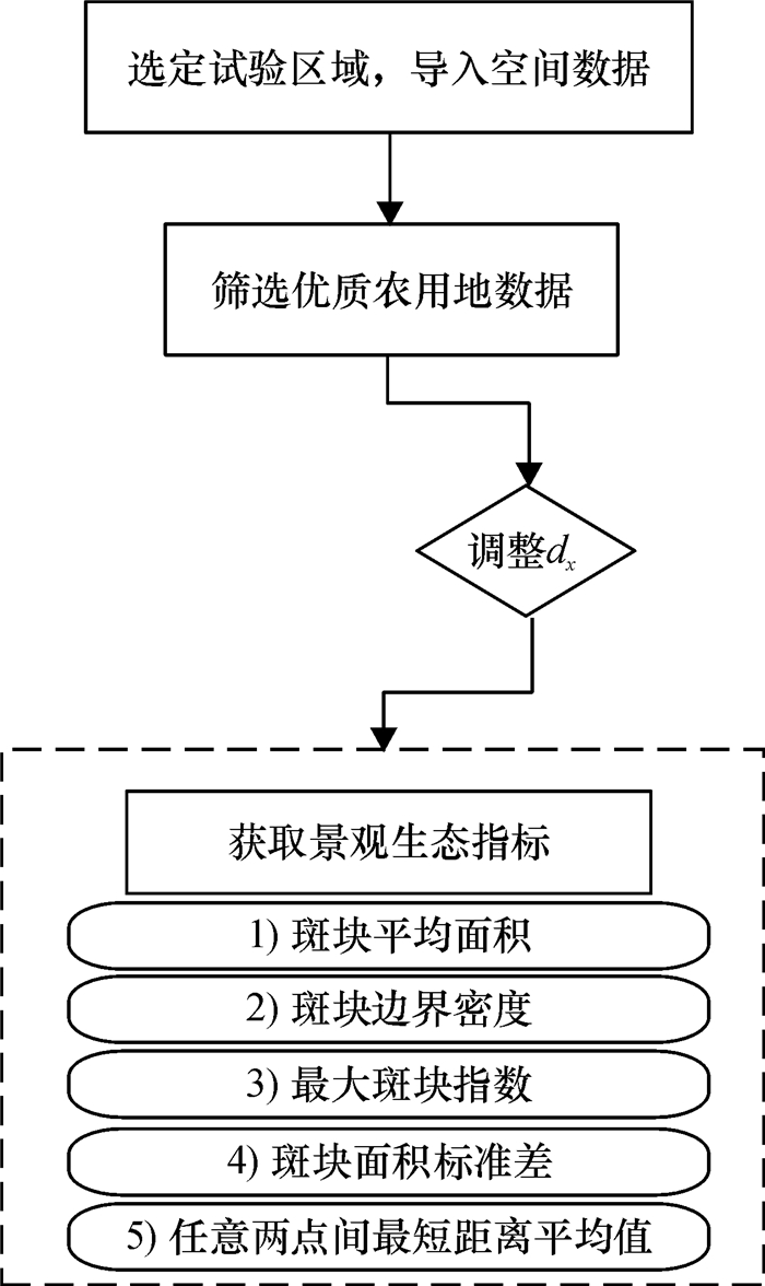
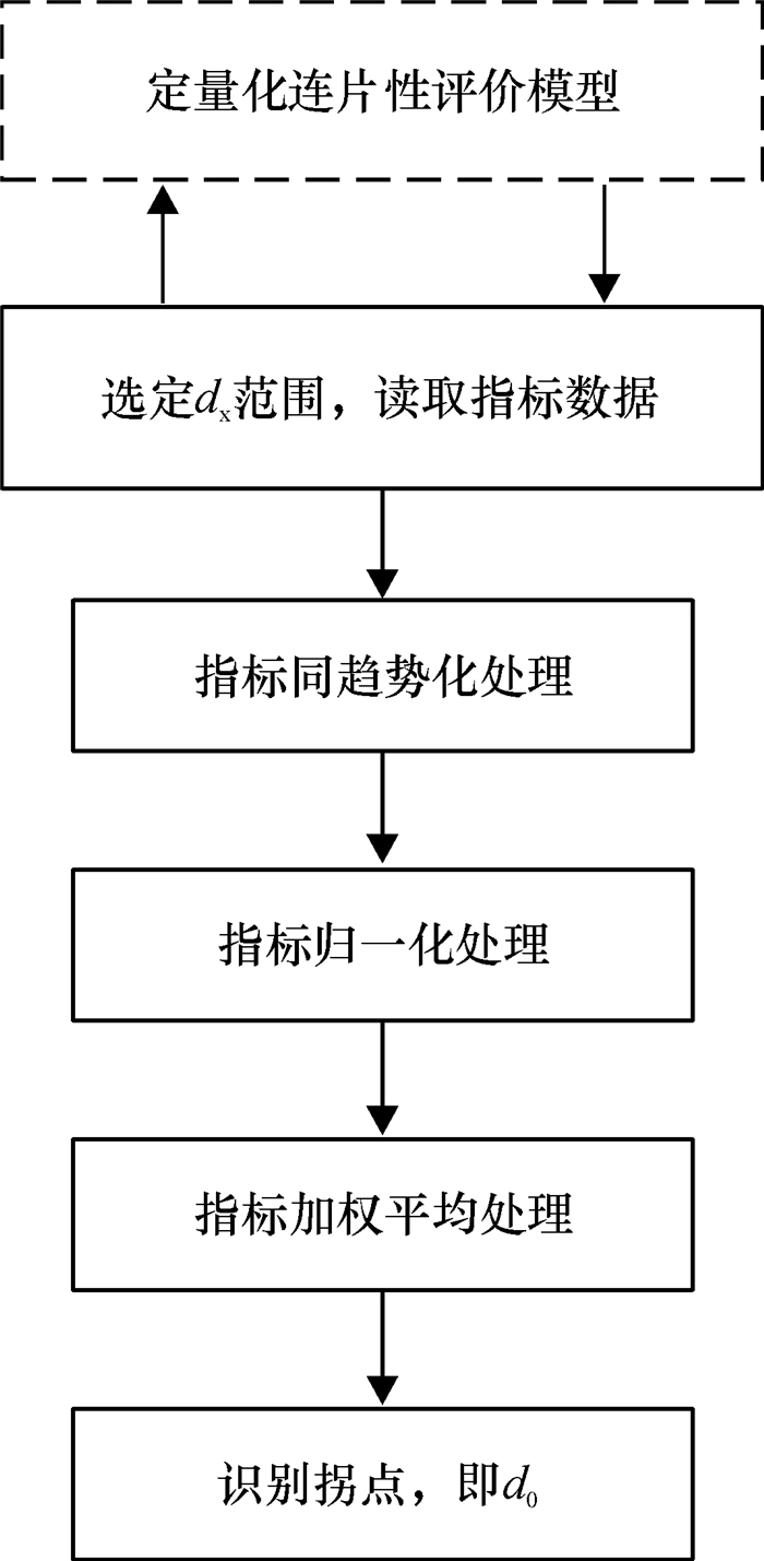
方法通过引入景观生态指标,应用GIS平台的空间数据处理功能获取指标数据,实现连片性评价的定量化;基于GIS平台的缓冲功能,模拟设定不同阈值(dx)时连片性的变化;观察dx在一定范围内变化时连片性的变化曲线图,识别农用地连片的最优阈值(d0)。
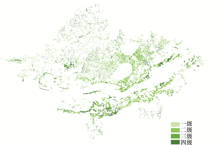
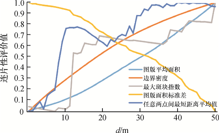
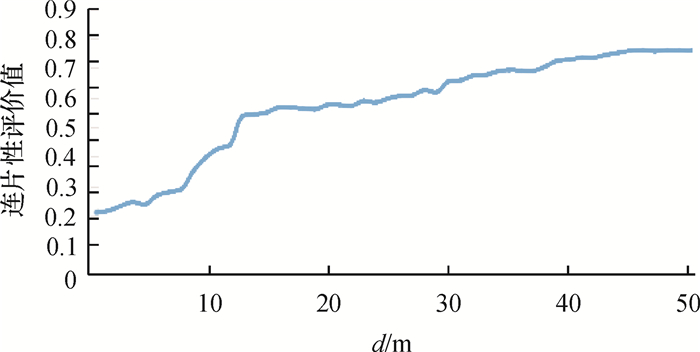
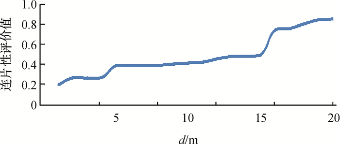
结果以广东省罗定市2010年优质农用地空间数据为例,当农用地整治连片间距范围在0~50 m时,阈值d0为12 m,因此建议将全区间距≤12 m的相邻地块进行连接。对佛山市高明区农用地数据重复试验,得到了该地区最优连片阈值,表明该方法可用。
结论基于景观生态指标确定农用地连片阈值,具有直观、可靠和普适的优点,可以为全国范围内的农用地整治工作提供参考。
Abstract:ObjectiveConcentrated connectivity is the propulsion in current farmland consolidation, and concentrated connectivity threshold has a direct effect on engineering cost. This research focuses on studying the adjustment method of concentrated connectivity threshold based on landscape ecological indexes.
MethodFive landscape ecological indexes, which were obtained based on special processing functions in GIS platform, were used to achieve the quantitative evaluation of farmland connectivity. Based on the buffer function in GIS platform, the changes of farmland connectivity were simulated by setting different threshold dx. The curve of farmland connectivity was observed when the threshold dx was changing, and the optimal connectivity threshold d0 was identified.
ResultTaking farmland in Luoding City, Guangdong Province as an example, when the consolidation threshold ranged from 0 to 50 m, the optimal connectivity threshold d0 was 12 m. The farmlands, which separated less than or equal to 12 m, should be connected. As the experiment was repeated in Gaoming District of Foshan City, the optimal connectivity threshold was also found, which testified the feasibility of this method.
ConclusionThe method, which finds the optimal connectivity threshold based on landscape ecological indexes, is straightforward, reliable and pervasive, and can provide the technical reference for national farmland consolidation.
-
-
![]()
图 2 最优连片阈值d0识别模型
Figure 2. Identification model of the optimal connectivity threshold d0
![]()
图 3 罗定市2010年优质农用地质量分布
Figure 3. Distribution of high quality farmland in Luoding City, 2010
![]()
图 4 罗定市农用地连片性评价指标变化
Figure 4. Index variation of connectivity evaluation in Luoding City
![]()
图 6 高明区连片性评价指标变化
Figure 6. Index variation of connectivity evaluation in Gao-ming Region
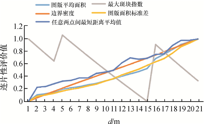
表 1 评价指标对比
Table 1 Comparison of evaluation indexes
项目 图斑平均
面积/hm2边界密度/
(km·hm-2)最大斑
块指数图斑面积
标准差任意两点间
最短距离平均值/m2010年(基期) 5.007 0.366 0.022 23.624 61.839 d0=12 m 6.783 0.210 0.035 32.241 47.592 2011年(规划期) 5.289 0.352 0.030 30.343 57.827  下载: 导出CSV
-
[1] 张清. 江西省土地整治战略研究[D]. 南昌: 江西农业大学, 2012. [2] 刘彦随. 科学推进中国农村土地整治战略[J]. 中国土地科学, 2011(4):3-8. http://youxian.cnki.com.cn/yxdetail.aspx?filename=ZGTN20170726004&dbname=CAPJ2015 [3] 刘彦随.科学推进中国农村土地整治战略[J].中国土地科学, 2011(4):3-8. doi: 10.11821/xb201006011 [4] 朱晓华, 陈秧分, 刘彦随, 等.空心村土地整治潜力调查与评价技术方法:以山东省禹城市为例[J].地理学报, 2010(6):736-744. http://www.cnki.com.cn/Article/CJFDTOTAL-NYGU201401023.htm [5] 冯应斌, 杨庆媛.转型期中国农村土地综合整治重点领域与基本方向[J].农业工程学报, 2014, 30(1):175-182. http://www.cnki.com.cn/Article/CJFDTOTAL-NYGU200807016.htm [6] 周尚意, 朱阿兴, 邱维理, 等.基于GIS的农用地连片性分析及其在基本农田保护规划中的应用[J].农业工程学报, 2008, 24(7):72-77. [7] 刘巧芹, 张敬波, 阮松涛, 等.我国农用地整治潜力评价的研究进展及展望[J].水土保持研究, 2014(2):327-332. http://youxian.cnki.com.cn/yxdetail.aspx?filename=ZGTN20170726004&dbname=CAPJ2015 [8] 杨绪红, 金晓斌, 郭贝贝, 等. 2006—2012年中国土地整治项目投资时空分析[J].农业工程学报, 2014, 30(8):227-235. http://www.cnki.com.cn/Article/CJFDTOTAL-NYGU201206041.htm [9] 黄辉玲, 吴次芳, 张守忠.黑龙江省土地整治规划效益分析与评价[J].农业工程学报, 2012, 28(6):240-246. http://www.cnki.com.cn/Article/CJFDTOTAL-XNND201408022.htm [10] 孙祥龙, 涂建军, 黄九松, 等.基于ArcGIS空间分析技术和农用地分等成果划定基本农田:以重庆市秀山县为例[J].西南大学学报(自然科学版), 2014, 36(8):130-135. http://www.cnki.com.cn/Article/CJFDTOTAL-ZTKX201207005.htm [11] 沈明, 陈飞香, 苏少青, 等.省级高标准基本农田建设重点区域划定方法研究:基于广东省的实证分析[J].中国土地科学, 2012, 26(7):28-33. http://www.cnki.com.cn/Article/CJFDTOTAL-SDDI201402023.htm [12] 张保华, 王雷, 白振华, 等.基于景观格局指数的基本农田保护区集中连片性研究:以济南市历城区为例[J].山东国土资源, 2014(2):80-82. http://www.cnki.com.cn/Article/CJFDTOTAL-ZTKX201202016.htm [13] 卢艳霞, 黄盛玉, 王柏源, 等.农村土地整治创新模式的思考:基于广西壮族自治区崇左市龙州县"小块并大块"的启示[J].中国土地科学, 2012, 26(2):84-87. http://www.cnki.com.cn/Article/CJFDTOTAL-ZTKX201409011.htm [14] 崔勇, 刘志伟.基于GIS的北京市怀柔区高标准基本农田建设适宜性评价研究[J].中国土地科学, 2014, 28(9):76-94. http://youxian.cnki.com.cn/yxdetail.aspx?filename=ZGTN20170726004&dbname=CAPJ2015 [15] 杨绪红, 金晓斌, 管栩, 等. 2006—2012年中国土地整治项目空间特征分析[J].资源科学, 2013(8):1535-1541. doi: 10.3969/j.issn.1002-6819.2012.18.033 [16] 刘文平, 宇振荣, 郧文聚, 等. 土地整治过程中农田防护林的生态景观设计[J]. 农业工程学报, 2012, 28(18): 233-240. [17] 我国土地整治的实践创新与理论进步:国土资源部土地整治中心副主任郧文聚研究院接受本刊专访[J].上海国土资源, 2012(33):1-6. doi: 10.3969/j.issn.1004-874X.2015.23.030